Contact
Biological mapping
Børge Holte
+47 77 60 97 53
Geological mapping
Terje Thorsnes
+47 73 90 42 75
Bathymetry
Hanne Hodnesdal
+47 51 85 88 23
Information officer
Beate Hoddevik Sunnset
+47 55 23 85 16
Published: 21.09.2010 Updated: 18.08.2022
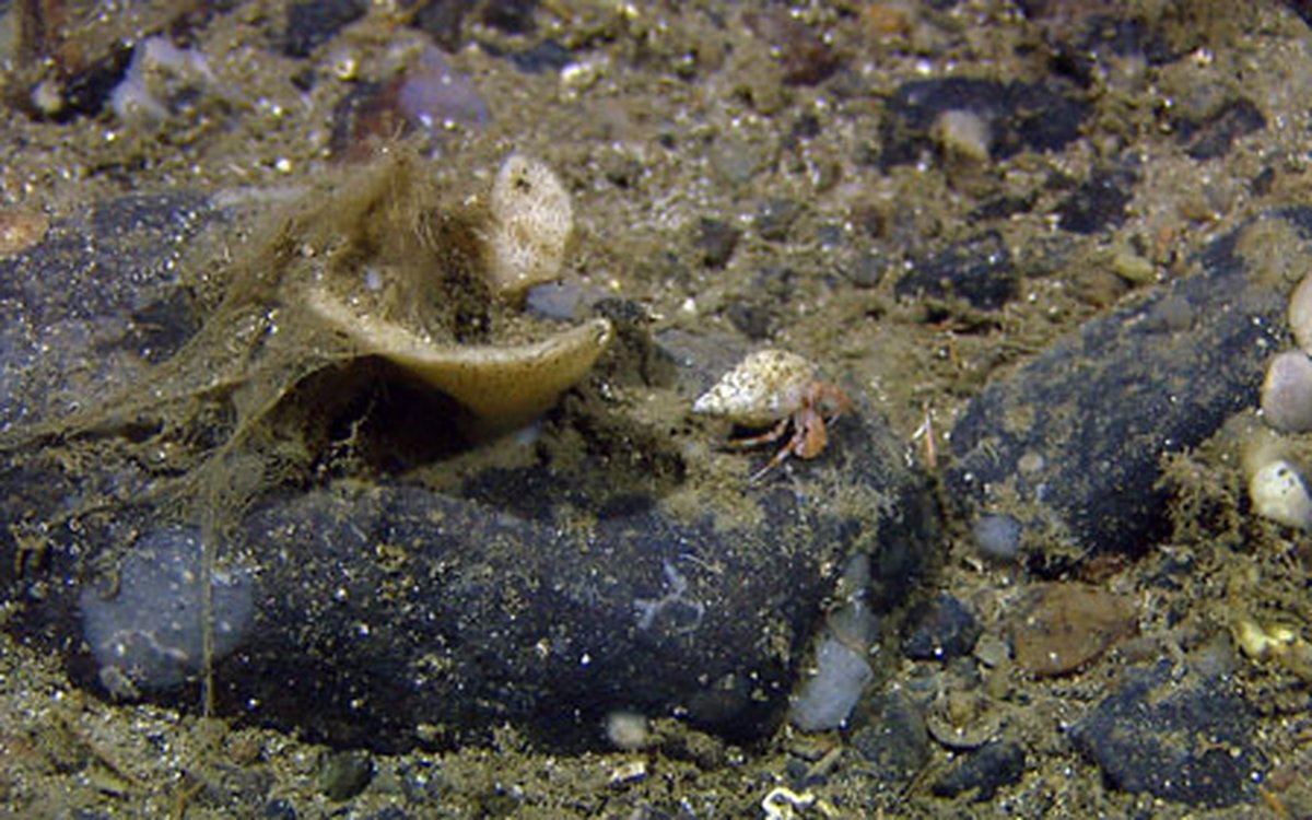
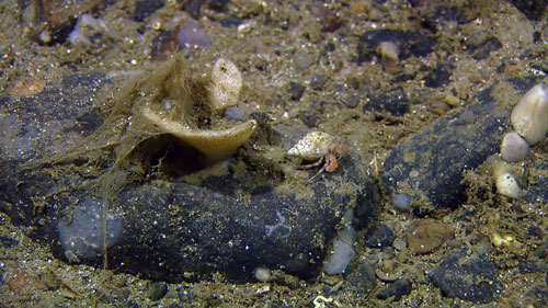
The west coast of Sørøya drops off into a glacially eroded trough at about 350 meter water depth. At the bottom of this trough we observed a seafloor with gravel and stones. This coarse sea bottom was covered by several different species of encrusting or erect sponges (Porifera) and the Galatheoidea crustacean Munida was distributed between the stones (figures 2 and 3).
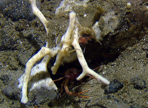
The stones give the animals hiding places and shelter, but also provide elevations from where it is possible to catch food particles coming along with the bottom current. This can be done by a spiderweb of mucous strings as seen clinging to the white funneled shaped sponge in figure 4. Located at the edge of a stone in figure 4, the hermit crab can use its sensory hairs on its legs and antenna as receptors to identify the scent of food sources or potential mates within the water current.
During the last glaciations, glaciers and ice sheets brought a lot of coarse-grained sediments to the continental shelf. Several ice streams flowed through the fjords and then followed the glacial troughs towards the shelf edge (figure 5). The eroded material was transported by the ice and subsequently deposited as till along the troughs and continental shelf. During the deglaciation of the shelf and after the ice had retreated to the coastal area, icebergs drifted around and deposited ice rafted debris (drop stones) on the seafloor. In this period the content of suspended silt and clay particles in the water masses was high, and much glacimarine sediments were deposited in deep depressions and troughs where the bottom currents normally are weak. The deep trough west of Sørøya is unusual as only the coarse-grained sediment (coarse sand, gravel and stones) is observed. This is due to a strong bottom current which prevented the deposition of fine-grained sediments during the deglaciation. Presently the current is still strong enough to maintain the prevention of deposition of fine-grained sediments.

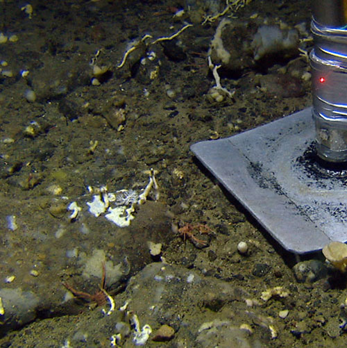
On our way up to shallower areas west of Sørøya we discovered an area covered by sand. Here, the animal life was not as visible and less diverse as in the channel we had left.
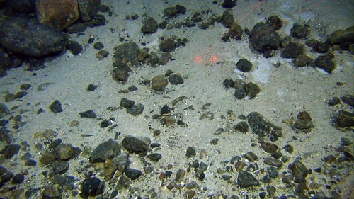
Figure 6. Sandy bottom with stones was discovered on the way up from the deep channel (300m) and to shallower areas west of Sørøya. The two red dots are laser beams which specify a distance of 10cm. This is a reference used to measure the size of stones and animals observed on the bottom.
In order to study the invisible animal life of this area with the video monitoring, we need to study the stones close up. This is possible when the Campod is stationary on the seabed, at which point the powerful lens can clearly focus in on objects as small as 2cm for a detailed inspection.
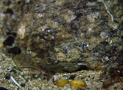
Figure 7. Close-up of details on a stone shows white lines of sessile calcareous Bryozoa or tubes made by Polychaeta bristle worms. Below the stone, yet another Munida has found a place to live, and in front of the picture two yellow bivalves of Astarte sp dwells. Down in the right corner a Ditrupa polychaeta, located inside a white tube, are exposing its delicate tentacle crone. The bottom is covered by dead fragmented bivalves.
The strong bottom current also prevents deposition of mud in depressions closer to the coast. In these depressions we found sand ripples indicating a quite strong current.
Here we discover large individuals of the carnivorous sea star Hippasterias phrygiana (figure 8). It hunts on other bottom animals such as bivalves, snails, crustaceans, worms and other echinoderms (the family where sea stars, brittle stars, sea cucumber and sea lilies belong).
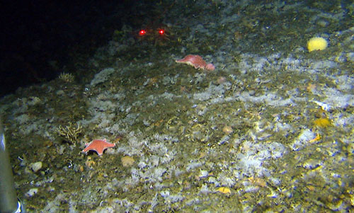
Figure 8. A topographically heterogeneous landscape consisting of crystalline bedrock partly eroded by ice during the last glaciation. Here we discovered the sea star named Hippasterias phrygiana. The white color on the seabed is mainly Bryozoa. To the left in the picture you see the leg of the Campod.
At some places the seabed was covered by a branchy layer of Bryozoa (figure 9). Each of the branches looks like an apartment block with houses stacked upon each other. Hundreds of individuals (zoides) sit inside its personal apartment (zoecium) with a door opening (orifice) which, in many Bryozoa species, can be closed by a door (operculum). Each individual has a tentacle organ (lophophore) upon its head. The opening of the operculum enables the lophopore to protrude and by flicking actively it catches food particles from the water current passing by. This food mainly consists of tiny planktonic organisms.
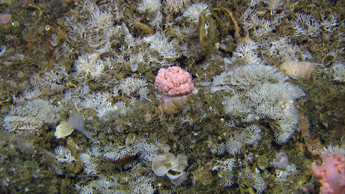
Figure 9. A seabed covered by several species of white colonizing Bryozoans. A pink retracted soft coral (Alcyonacida) of the family Nephtheidae has made its home in the middle of the bryozoan forest.
This was a taste of the recordings we have done so far within the first 30 hours of the autumn survey with MAREANO. There are still 288 hours ahead of us before another team will take over for a new 14 days period at sea. We are 14 busy MAREANO people and 3 MAREANO guests on board who work 24 hours a day and we will be back later with news from the bottom.