
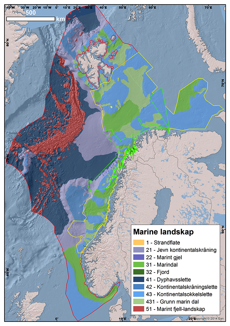
Marine landscape
In our mapping, landscape is defined as "large geographical areas with a visually homogeneous character”. The landscape classification in the sea areas that have been mapped must be full-coverage and non-overlapping. That means that every point must be classified as belonging to a single landscape. MAREANOs mapping has so far covered 10 types of landscapes.
Bathymetric data enable us to determine which areas should be classified as plains, continental slopes, valleys and strandflats. We use a GIS-based method that employs low-resolution depth data and parameters that can be extracted directly from these to enable us to define the boundaries of these features in a manner that is reproducible and as far as possible does not involve interpretation.
Examples of mapped landscapes:
- Strandflat. The crystalline platform which characterises large parts of the Norwegian coast and contrasts sharply with the sedimentary continental shelf in the way it is built up and its topography.
- Continental slope. The transition zone between the continental shelf and the deep ocean. It is transected by large and small submarine canyons in several places.
- Marine valleys. Eroded into the continental shelf and the strandflat, and a result of concentrated glacial erosion during the ice ages.
- Fjords. Over-deepened erosion forms which cut into the land and terminate at a threshold.
- Abyssal plain. Starts at the foot of the continental slope and embraces all deep-sea areas with low relief, including the continental rise.
- Continental shelf plain. The residual landscape on the continental shelf, where the relief is predominantly low, but there are nevertheless areas that are morphologically similar to other types of landscape (particularly shallow marine valleys).
- Marine mountain landscape. Seabed area with high relief but without clear valley shape. In Norwegian areas, this landscape type is mainly found along the mid ocean ridges.
Four parameters in particular are used to determine the boundaries between the various types of landscape:
- Relative relief. This is a measure of the variation in height within a given area. A neighbourhood of 1 km² is used for landscape mapping, and 50 m relative relief per km² is regarded as the upper limit for a plain.
- Angle of slope. Calculated on the basis of the difference in height between adjacent cells in a raster.
- Terrain noise. Describes the degree of local topographical variation. Several GIS tools will capture this, including curvature analysis. In landscape mapping, terrain noise is particularly used to distinguish the crystalline strandflat from the sedimentary continental shelf plain.
- "Relative position" (bathymetric positioning index, BPI). Indicates whether a point lies higher or lower than the average for a neighborhood of a certain size. If a large neighbourhood is chosen, large features in the terrain (such as marine valleys and canyons) will be obtained, whereas small neighbourhoods will bring out more local variations in the terrain.
All the relevant landscapes can be identified automatically by combining these parameters in various ways using GIS. However, there will still be a need for some interpretation when the boundaries are to be digitalized at the detailed level. The completed landscape map becomes part of the MAREANO habitat mapping, but also has other areas of use.
Contact

Lilja Rún Bjarnadóttir
Geological Survey of Norway
Geological mapping
Geologist
944 97 728