
Contact
Biological mapping
Børge Holte
+47 77 60 97 53
Geological mapping
Terje Thorsnes
+47 73 90 42 75
Bathymetry
Hanne Hodnesdal
+47 51 85 88 23
Information officer
Beate Hoddevik Sunnset
+47 55 23 85 16
Published: 18.09.2012 Updated: 03.10.2022
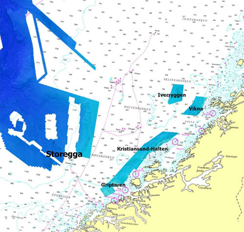
The new data which have been incorporated into the shadow relief map layer cover:
1. The Griptaren-Kristansund-Halten coastal zone (data acquired by the Norwegian Defence Research Establishment, FFI)
2. Vikna (data acquired by the Norwegian Defence Research Establishment, FFI)
3. Parts of the Storegga Slide (data supplied by Statoil and acquired on behalf of the Norwegian Deepwater Programme Seabed Project)
4. Iverryggen (data acquired by MAREANO in April 2012).
In the case of data sets 1 and 2, shadow relief displays are based on a 50m × 50m terrain model, since these are in territorial waters (within 12 nautical miles of the baseline), where data of higher resolution are classified by the Norwegian military. In the case of data sets 2 and 3, the terrain models used have a resolution of 25m × 25m.
For data sets 1, 2 and 4, shadow relief displays are based on provisional grids. When the data sets have been fully processed the map service will be updated with shadow relief displays based on the final grids.
The map service will be updated as data are acquired (provisional terrain models) and data are processed and approved (final terrain models).
Read more about bathymetric mapping.