Goto main content
e Umbellula

New general biotope map for the Barents Sea

Mareano has now published an updated general biotope map for the Barents Sea. This map more than doubles the area for which biotopes distribution has been predicted in this area, and provides the first indication from Mareano results of distinctive habitats occurring in Arctic waters and north of the Polar Front.

Have a closer look at the map here.

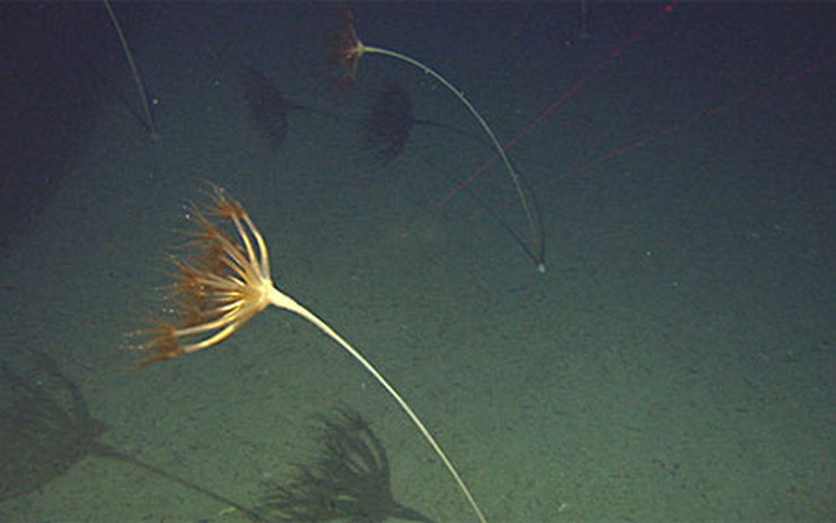
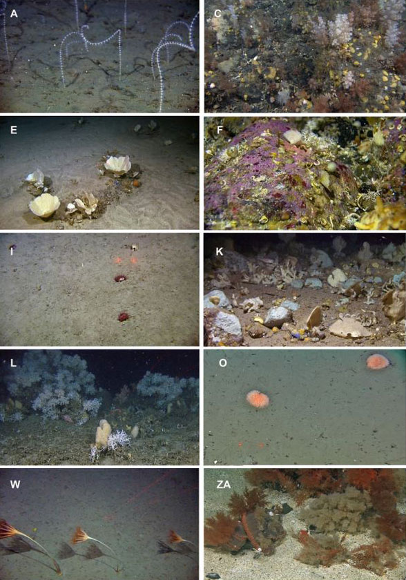
A total of 27 distinct biotopes were identified within the study area on the basis of the species composition as identified from Mareano video data. Each biotope represents a characteristic suite of animals living on the seabed in particular environmental conditions. Below we see some examples of the different biotopes, giving a flavour of the variety across different water masses.

Figur biotoper
Examples of 10 contrasting biotopes identified with TWINSPAN of the species data from the video analyses. The letters represent the biotope abbreviation corresponding to Table 3. Arctic Intermediate Water Masses: A) Soft bottom coral garden dominated by pigtail coral (Radicipes gracilis) on the slope south west of Svalbard. C) Encrusting sponges and tunicates, and cauliflower coral on gravelly bottom. E). Sponge garden on sandy bottom dominated by Phakellia sp. and Axinella sp. Atlantic Water: F) Hard substrates dominated by encrusting red algae in strandflat areas. I). Mixed sediments dominated by cup corals (Flabellum macandrewi). K). Sponge garden with a variety of axinellid sponges on mixed bottom.  L). Cold water coral reef (Lophelia pertusa) in the south western part of the study area. The same biotope is also represented with soft bottom sponge aggregations dominated by Geodidae sponges. O). Muddy bottom on the shelf on the shelf in central parts of the study area dominated by the anemone Liponema multicornis. Norwegian Sea Deep Water: W). Sandy substrate on the lower slope dominated by the sea pen Umbellula encrinus. Arctic Water: ZA) Shallow, sandy, gravelly bank dominated by the holothurian Cucumaria frondosa, the hydrozoan Thuiaria obsoleta, and the bryozoan Eucratea loricata.

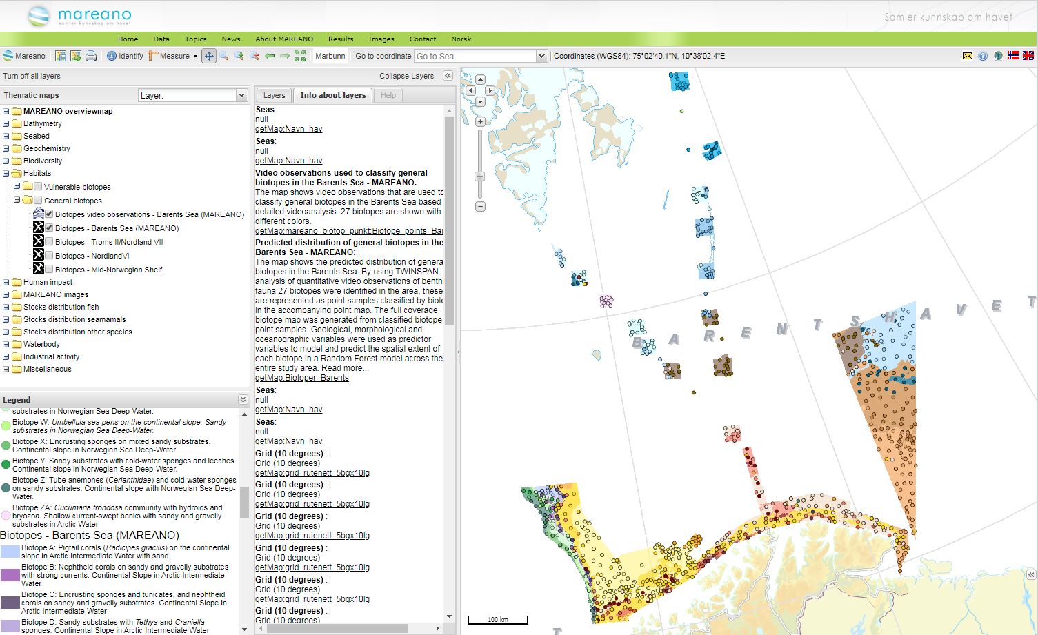
Maps of biotope distribution are provided in two complementary formats:

  1. A point map showing observed sample points (200 m sections of video data) classified by biotope.
  2. A full coverage raster map showing the predicted distribution of biotopes across the entire mapped area. This map is based on the point map and full coverage environmental data which facilitates prediction between observed points.

The large area mapped and large volume of samples included have made it necessary to update the methods used for classification and modelling as compared to those used previously in Mareano. The new approach is more robust and suitable for analysis of large datasets and we look forward to applying this approach when updating biotope maps for all Mareano areas to provide a harmonised output.  
 
Further details on the techniques used for classification, modelling and prediction used in the Barents Sea General Biotope Map are available here.

Contact

Photo of Margaret Dolan

Margaret Dolan

Geological Survey of Norway (NGU)
Researcher
+47 73 90 42 67
Photo of Pål Buhl-Mortensen

Pål Buhl-Mortensen

Institute of Marine Research
Scientist
+47 484 03 792