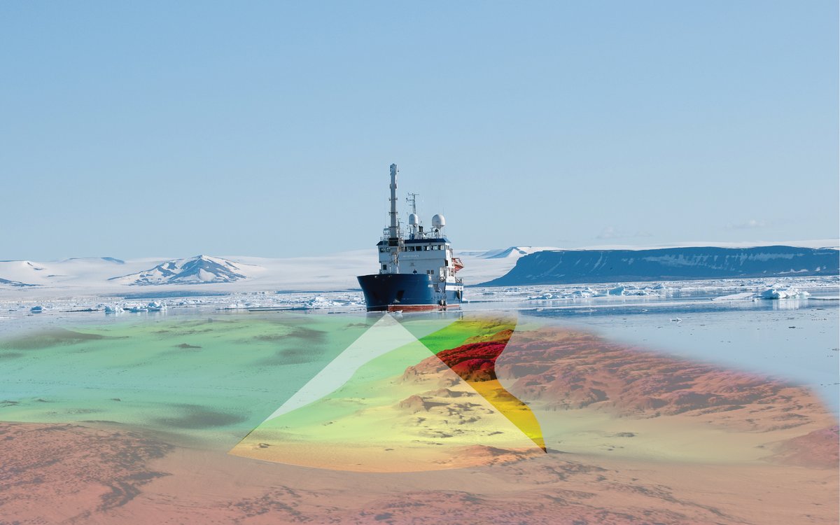
HYDROGRAPHY: Bathymetric surveying using multibeam echosounder. The width of the surveyed belt is approximately 3.5 times the sea depth. Illustration: Norwegian Mapping Authority Hydrographic Service
HYDROGRAPHY: Bathymetric surveying using multibeam echosounder. The width of the surveyed belt is approximately 3.5 times the sea depth. Illustration: Norwegian Mapping Authority Hydrographic Service
Published: 16.12.2014 Updated: 20.07.2022
If bathymetric data of adequate quality and resolution already exist, these will be used. Sources of existing data are the Norwegian Mapping Authority Hydrographic Service (NHS), the Norwegian Defence Research Establishment (FFI), the Norwegian Petroleum Directorate, the petroleum industry, universities, research institutes and other bodies. New bathymetric mapping under the auspices of MAREANO has mainly taken place in the Barents Sea and marine areas off the coast of Lofoten (see the summary map below). The seabed surveying is conducted using multibeam echo sounders aboard surface vessels, as shown in the illustration below.
Since 2006 all bathymetric surveys at water depths of less than 1200 metres have been carried out using the EM710 echo sounder manufactured by Kongsberg Maritime. This provides a dot spacing of approximately 0.9 metres at a water depth of 100 metres, 1.8 metres at 200 metres depth, and so on. This makes it possible to create high resolution (5 metre grid) terrain models which can be used to interpret highly detailed seabed features (coral reefs, ripple marks, etc.). In areas with more than 1000 metres water depth, the EM300 echo sounder is mainly used, and provides coarser resolution. In 2011, the EM302 was also used in deepwater areas, and effectively provides the same number of measurements as the EM710, although because of the water depth the dot spacing is greater. The EM302 provides a dot spacing of 12 metres at a water depth of 1500 metres and a spacing of 24 metres at twice that water depth.
Echo sounders are normally set up to measure 60 degrees on either side of the vertical, so that a boat line covers a belt on the seabed which is 3.5 times as wide as the water depth. In other words, if the water depth is 100 metres, a 350-metre wide belt is covered, in 200 metres of water the belt is 700 metres wide, and so on.
Measurements from the echo sounders also provide reflectivity (backscatter) data which contribute information about the nature of the seabed (hard or soft). This provides a basis for interpretations of, among other things, sediment distribution and habitat type. Since 2010, water column data have also been acquired using echo sounders. These are reflections of the sonic pulse as it travels through the water, before it reaches the seabed. Such data can be used to detect gas bubbles in the water column, for example.
In addition to echo sounders, instruments are needed to measure the vessel’s position, motion (course, speed, heave, roll and pitch) and the velocity of sound in the water, both close to the sonar transducer and thorough the water column. The interaction between the various sensors is important, and the installation of the equipment must be accurately calibrated with reference to the vessel’s coordinate system. For details see the technical specification for bathymetric mapping in MAREANO and The Norwegian Mapping Authority's web pages (In Norwegian).
Large waves result in poor quality bathymetric data, partly because air bubbles are created under the vessel which interfere with the echo sounder measurements. To some extent this can be compensated for by sailing survey lines with a following sea, rather than against it, or by reducing the aperture of the echo sounder and planning a greater overlap between survey lines. All these measures will result in slower progress. However, if the weather worsens, at some stage the noise will be so strong that recording must be suspended. At what sea state this will take place depends on, among other things, the size of the vessel, the design of the hull and the location of the echo sounder.
To obtain the best possible geographical positioning, correction data are downloaded from GPS satellites following the actual field work, and these are used to refine the positioning data. The recorded bathymetric data shall be filtered to remove noise and checked for gaps. This involves a certain amount of manual work and is therefore a time-consuming process.
Hydrographic surveying is expensive. The price depends on the water depth, with the price per square kilometre being highest in shallow water areas. Some of the hydrographic surveys have been carried out using government owned vessels: Hydrograf (the Norwegian Hydrographic Service), H.U. Sverdrup (FFI) and G.O. Sars (Institute of Marine Research). However, in general, hydrographic services have been purchased on the international market. About 40% of the funding allocated to MAREANO has been used to finance bathymetric mapping. This includes hydrographic surveying (field work), data processing (filtering of noise), administration of bathymetric data and the production and distribution of products and services.
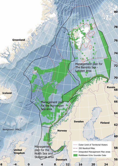
COVERAGE MAP: Areas covered by multibeam echosounder as of January 2019. An up-to-date coverage map is available from the MAREANO map service.
The role of the Norwegian Mapping Authority Hydrographic Service as a national administrator of bathymetric data places considerable demands on quality assurance and the establishment of bathymetric data in practical, modern administration and distribution systems.
The completed data sets are used to produce data grids of 5, 25, and 50 metre resolution. Inside the territorial boundary the resolution is limited to 50 m in compliance with Norwegian military classification regulations. The terrain models are available free of charge to members of the Norwegian government's Norway Digital initiative. Non-participants in Norway Digital may order data for a charge by contacting the Norwegian Mapping Authority’s distribution service by e-mail.
Read more about bathymetric data and digital terrain models of the seabed at kartverket.no.
A WMS map service with shadow relief images has been created to visualise detailed bathymetric conditions of seabed features (see the illustration below). Map services have also been created which include a summary of general bathymetric conditions in Norwegian waters, as well as access to available bathymetric data administered by the Norwegian Mapping Authority Hydrographic Service. Most WMS services are open and can therefore be freely used in other applications and GIS tools. See the overview of the Norwegian Mapping Authority's open display services at geonorge.no.
Further information about products and distribution can be found under the following menu on the Norwegian language site www.mareano.no: Datanedlasting > Statens kartverk Sjø (in Norwegian).
All products and services are available for download and use through the “Norway Digital” initiative, in accordance with MAREANO’s data policy. Access to the map services is also available by way of mareano.no and geonorge.no.
Operators who are to carry out bathymetric mapping for MAREANO must comply with the technical specification for bathymetric mapping in MAREANO, also known as “the MAREANO standard for bathymetric mapping”.
View the technical specification for bathymetric mapping in MAREANO (pdf).
If you have any questions about, or comments on, the specification, contact Arne E. Ofstad or Hanne Hodnesdal at the Norwegian Mapping Authority, Hydrographic Service.