Contact
Biological mapping
Børge Holte
+47 77 60 97 53
Geological mapping
Terje Thorsnes
+47 73 90 42 75
Bathymetry
Hanne Hodnesdal
+47 51 85 88 23
Information officer
Beate Hoddevik Sunnset
+47 55 23 85 16
Published: 30.09.2010 Updated: 18.08.2022
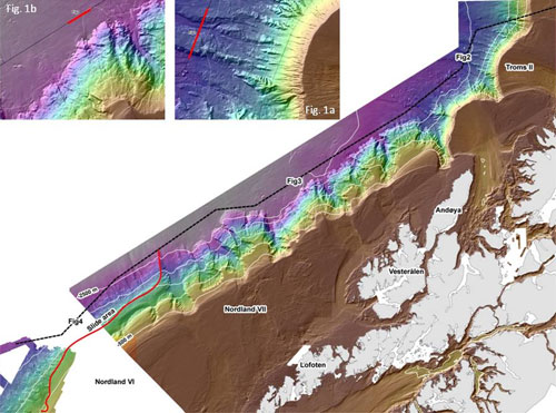
Figure 1. The southern part of the route from Troms III to Nordland VI (black line) plotted on a map showing areas mapped with multibeam echosounder. The location of Topas examples (Figs. 2-4) are shown as well as detailed bathymetric maps from these locations (Figs. 1a and 1b). The red line shows the northeastern limit of a 300 km long area of slide activity along the continental slope.
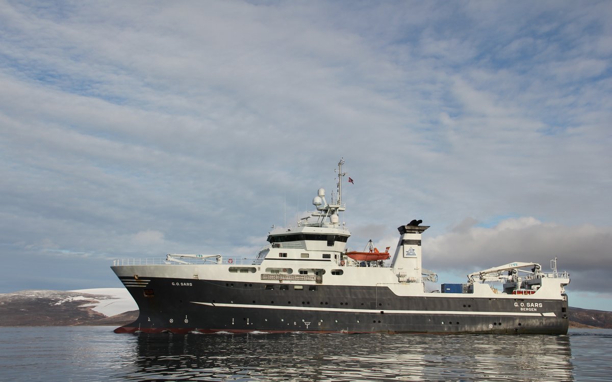
After finishing the first priority stations in the Troms III area, "G.O. Sars" headed towards Nordland VI, where many stations at deep water are on the priority list. On our journey southwards we collected acoustic data with Topas in order to obtain new information about the sediments below the seafloor. We also crossed some second priority locations along the route. Although "G.O. Sars" did 10-11 knots, we collected data of high quality. Along southern Troms and off Vesterålen and Lofoten we followed the deep sea plain slightly west of the continental slope (Fig. 1). Water depths of the very gently sloping deep sea plain are more than 2000 m, and the landscape is almost flat compared to the irregular continental slope which has slope gradients of 5-10 degrees.
In some areas, the high frequency sound waves penetrated nearly one hundred meters into the seabed sediments, and the Topas has given new data of importance for understanding the geological development of the area. For instance, the data have shown that the ridges in the lower slope off southern Troms are made up of parallel-layered sediments (Figs. 1a and 2). From the slightly wavy layers we can imagine the old landscape which existed before slide activity started.
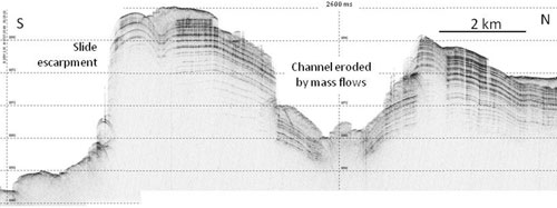
Figure 2. Topas image showing two ridges separated by a channel (for location see Fig. 1a). The water depth is about 2000 m, and the distance between the horizontal lines is 40-45 m (depending on the sound velocity in the sediments). The layered succession probably comprises fine-grained sediments. The age of the sediments is unknown, but we think they may be several million years old. Note the variable thickness of the slide deposits at the seafloor, and that the mass movements following the channel have eroded deeply into the stratified sediments.
Topas (Topographic Parametric Sonar) is a kind of strong echosounder, with ability to penetrate into the upper sediment layers, if the topographic and geological conditions are favorable. Under good conditions we can see up to 130 m below the sea floor. The emitted sound beam has a frequency of 2-6 kHz, and is reflected from the seafloor and the layers directly below. The width of the sound beam is 4-5 degrees, which is very narrow compared to other bottom-penetrating echosounders. This gives us the possibility to study the geology directly under the seafloor in great detail, and in high resolution. Under favorable conditions, half a meter thick layers may be identified. The research vessel "G.O. Sars" is specially designed to generate low acoustic noise.
Another down-slope-trending ridge not far from this location has earlier been video-filmed in the MAREANO project, showing fine-grained sediments being exposed in near vertical slopes. Topas data show evenly thick layers and deep penetration, indicating that the sediments are fine-grained and poorly cemented. The age of the sediments is unknown, but we suggest that they may be 3-10 million years old. The sediments were deposited in the ocean during more quiet conditions than we have experienced over the last 1-2 million years, when glaciers have crossed the shelf and deposited till-like material on the upper part of the slope. Parts of these poorly sorted deposits were redistributed down-slope by slides and gravity currents. In Topas-data we recognize such deposits as incoherent or massive, and different from the stratified sediments which formed due to sediment particles falling out of suspension from the water column.
The Topas data show that slides have preferentially followed depressions like snow avalanches following the same ravines in the mountain valleys. Slides and other gravity flows have eroded channels, giving a characteristic landscape with parallel ridges (Figs. 1a and 2). The steep continental slope off southern Troms shows several slide escarpments and slide deposits, and some of the slides may be very large. The bathymetric maps show areas with slide blocks up to 60-70 m in height and several kilometers long (Buhl-Mortensen et al., 2010).
More than ten deep canyons cut into the continental slope off Lofoten and Vesterålen (Fig. 1). These canyons are the largest on the 3000 km long North-European continental margin from Ireland to Svalbard. Two of the canyons are incised more than 1000 m below their shoulders. Both slides and other mass movements have been important for the development of the canyons, and most of the eroded material has been deposited as wide submarine fans on the deep sea plain (see Figs. 1 and 3).
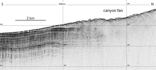
Figure 3. Topas image from the deep sea plain west of one of the deep canyons (for location see Fig.1b). Slides and other gravity flows transport material out of the canyons for deposition on wide, submarine fans. Note laminated sediments being deposited distally and in quiet areas between the fans. The water depth is about 2500 m, and the distance between the horizontal lines is 40-45 m in the sediments.
Multibeam bathymetry data collected some years ago by Norsk Hydro (now Statoil) showed that the huge Trænadjupet Slide reaches farther north than earlier imagined. The northern part of this data set is shown in the southwestern corner of figure 1. The MAREANO data set shows a slide landscape in the southern slope of Nordland VII. The southern part of our long Topas line ties these areas together, and we discovered slide deposits and slide escarpments in several places (Fig. 4). There is probably a continuous slide-affected area along the slope from the southern part of the Trænadjupet Slide and 300 km towards the northeast (the northeastern limit is shown by a red line in figure 1). We dont know if all the slides were triggered by the event that caused the 4000 years old Trænadjupet Slide, or if several slides of different ages have occurred.
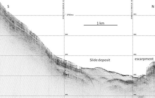
Figure 4. Topas line showing both slide escarpments and slide deposits in an area which has not yet been mapped by multibeam echosounder (for location see Fig. 1). The distance between the horizontal lines is 40-45 m in the sediments. A 300 km long section of the continental slope appears to have been affected by slides. The Trænadjupet Slide may be larger than previously assumed, or there may be several slides of different ages.
Til bunns i Barentshavet og havområdene utenfor Lofoten ny kunnskap fra MAREANO for økosystembasert forvaltning. Redaktører: Lene Buhl-Mortensen, Hanne Hodnesdal og Terje Thorsnes. Utgitt av: Norges geologiske undersøkelse 2010.