Contact
Scientist
Pål Buhl-Mortensen
+47 55 23 68 15
Information officer
Beate Hoddevik Sunnset
+47 55 23 85 16
Published: 08.03.2010 Updated: 18.08.2022
This map for the Eggakanten mapping area represents the first stage of nature-type mapping and is based on biological seabed observations in the field during MAREANO cruises in 2009 together with environmental variables derived from multibeam data, and interpreted geology. Use of statistical modelling and classification tools has allowed us to use these data to predict the distribution of general nature types across the whole area.
The following environmental variables were obtained directly or derived from multibeam data: Bathymetry, backscatter, slope, orientation (northness, eastness), terrain variability (rugosity, fractal dimension), relative position (bathymetric position index (BPI), plan, profile and mean curvature). All the variables are based on 50 m raster grids which are sufficient for regional nature-type mapping for which end products will be maps at 1:100 000 scale.
Many of the variables have been computed at multiple spatial scales to provide a measure of the morphology of the seabed across different distances. By considering these different scales we obtain a more representative suite of variables which may be of relevance to benthic communities. The scales are based on the size of the analysis window for computation of each terrain variable. These correspond to ground distances of 150 m, 450 m, 1050 m, 2450 m respectively. This provides a range of variables across a range of meso- to mega- habitat scales.
For work in the production of nature type maps the mean and standard deviation of all variables have been computed over a circular analysis window of diameter 200 m - this is to correspond with the distance over which video observations have been pooled in the biological analysis.
We have additionally included maps of sediment (grain size) distribution and sedimentary environment as environmental variables, since sediment type and energy near the seabed are important for benthic fauna.
Presence-absence data of taxa observed were recorded during recording of video transects. Registration of biota were made for intervals approx. 200 m long along each transect, and only taxa occurring in five or more sample intervals were included in analysis. This gave 401 video samples and 131 taxa (species and higher taxonomical units), Multivariate analysis (Detrended Correspondence Analsysis - DCA) was then performed on these data using PC-Ord software to identify biological groups that would reflect each nature type occurring.
Environmental variables derived from multibeam data that had strongest explanatory ability where selected using Forward selection with Monte Carlo permutation test in CCA (Canonical Correspondence Analysis, using the software Canoco).
By far the most important variable in this area is depth. Besides this, other broader scale environmental variables were found to be most important including mean slope, fractal dimension, northness. The standard deviation of a local scale BPI was also important particularly to some classes. MAXENT analysis also confirmed the importance of sediment grain size and sedimentary environment.
Several techniques are available for the production of maps from environmental variables and training samples (classes from identified biological groups) all based on some form of predictive modelling and classification. We have used two techniques in mapping the Eggakanten area:
Maps were made using the classifications from both DCA and cluster analysis. A comparison of these maps indicated that the maps based on DCA classes reflected patterns that made best sense in terms of separation of landscapes, bottom types and coherent occurrence of characteristic species. In the final map five nature type classes are recognized, which are based on DCA groups across the whole area with all samples.
We found that the MAXENT maps produced the best overall results. The models for each nature type have good performance statistics and the composite map shows an overall accuracy of 77% with respect to sample data. One particular advantage of MAXENT over the ArcGIS method is that it allows the inclusion of categorical data which means we can incorporate sediment information which helps to improve the maps. It also does not presume that each environmental variable is equally important to each class (nature type).
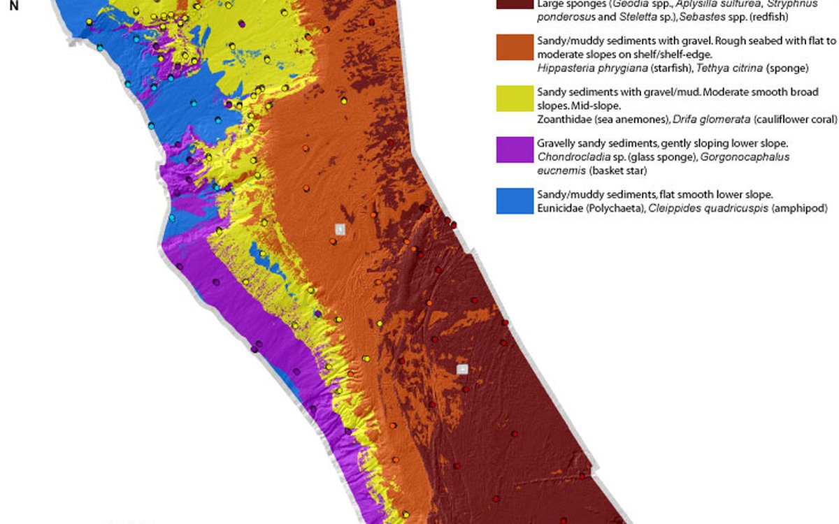
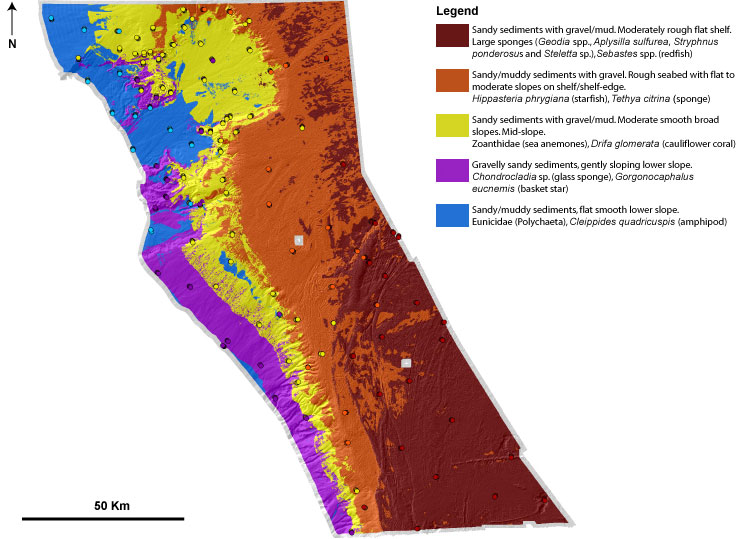
The map shows the likely distribution of nature types at the nature system level (NiN). Note that this is a preliminary raster map. Boundaries between nature types are based on relative probabilities for each nature type and are indicative only. These nature types may contain sub-groups of nature types defined at finer scale which will be represented in the final map based on detailed analyses of video records (these analyses are carried out in the lab using custom-built software).
Video data from Eggakanten will be analysed in detail during 2010 and used to produce a more detailed nature-type map for this area. This detailed video analysis will allow identification of seabed fauna to a lower taxonomic level. Use of these detailed analysis in multivariate analysis should facilitate division of the samples into more accurate, and potentially a greater number, of biological groups, which can be used together with environmental data to predict the distribution of nature types.
Further work will help to finalise boundaries between nature types and harmonise descriptions with NiN. Final nature-type maps for all MAREANO areas will be converted to polygon maps at 1:100 000 scale.
The table below is a summary of the physical and biological characteristics of each nature type. Depth region reflects the dominant area for this nature type - numerical depth ranges are for all biological samples grouped in this class. Other descriptors are based on overall values from terrain variables and sediment maps.
| Nature Type short physical description | Depth region | Sediments | Slope/Orientation (at scales of 1-2 km) |
Seabed roughness (at scales of 1-2 km) |
Typical fauna |
| Sandy sediments with gravel/mud. Moderately rough flat shelf. | Shelf (198 -515 m) |
Gravelly muddy sand, gravelly sand. Sedimentary deposition from suspension. Local erosion areas. | Generally flat, slightly north facing. | Moderately rough (iceberg ploughmarks, moraine ridges). | Large sponges (Geodia spp., Aplysilla sulfurea, Stryphnus ponderosus and Steletta sp.), Sebastes spp. (redfish). |
| Sandy/muddy sediments with gravel. Rough seabed with flat to moderate slopes on shelf/shelf-edge. | Shelf (254 -656 m) |
Gravelly muddy sand, gravelly sandy mud. Sedimentary erosion, with some local deposition. | Flat to moderate slopes at shelf edge, various orientations. | Rough (many iceberg ploughmarks). | Hippasteria phrygiana (starfish), Tethya citrina (sponge). |
| Sandy sediments with gravel/mud. Moderate smooth broad lopes. Mid-slope. | Slope (315 -1035 m) |
Gravelly sand, sand, sandy mud, small areas with sandy gravel. Sedimentary erosion. | Moderate broad-scale slopes, various orientations. | Smooth open slope and broad scale structures, local oderately rough areas. | Zoanthidae (sea anemones), Drifa glomerata (cauliflower coral). |
| Gravelly sandy sediments, gently sloping lower slope. | Lower slope (584 -1052 m) |
Gravelly sand, with local areas of sandy gravel, sand, gravelly sandy mud, sandy mud. Sedimentary deposition from bottom currents. | Moderate broad slopes, mainly south facing. | Smooth open slope and broad scale structures, local moderately rough areas. | Chondrocladia sp. (glass sponge), Gorgonocaphalus eucnemis (basket star). |
| Sandy/muddy sediments, flat smooth lower slope. | Lower slope (586 -1064 m) |
Sandy mud, gravelly muddy sand, sand. Sedimentary deposition from suspension. | Flat to moderate broad slopes, mainly south facing. | Smooth open slope and broad scale structures. | Eunicidae (Polychaeta), Cleippides quadricuspis (amphipod). |